
Guidebook for Tucson
Parks & Nature
Begin your trip at the Saguaro National Park West Visitor Center(3 miles away). A 15 minute video is very good at expounding on the history and Spirit of the Saguaro forest. Many hiking trailheads are only 3 miles away and span the park and adjoining Tucson Mountain Park & Gates Pass ( a favorite cyclist's training passage over the mountains) and many must see's like Native American petroglyphs...
320 locals recommend
Saguaro National Park
Begin your trip at the Saguaro National Park West Visitor Center(3 miles away). A 15 minute video is very good at expounding on the history and Spirit of the Saguaro forest. Many hiking trailheads are only 3 miles away and span the park and adjoining Tucson Mountain Park & Gates Pass ( a favorite cyclist's training passage over the mountains) and many must see's like Native American petroglyphs...
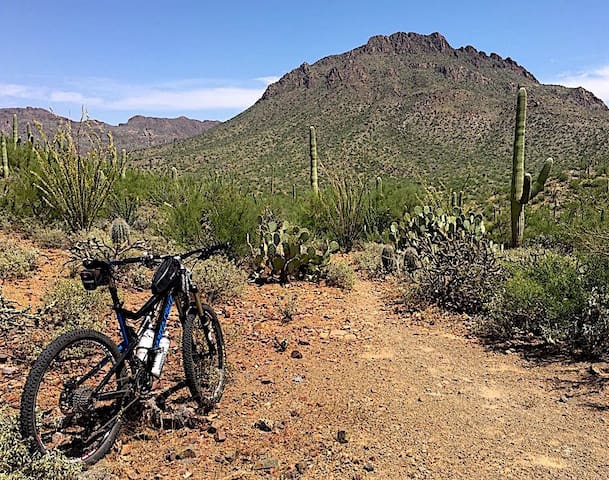
At approximately 20,000 acres, the park is one of the largest natural resource areas owned and managed by a local government in the U.S.
The park has approximately 62 miles of non-motorized shared-use trails. The park’s trails are open to hikers, equestrians, and mountain bikers, and provide a wide range of outstanding experiences, including technical challenges, and breathtaking views.
https://www.mtbproject.com/trail/7000581/tucson-mountain-park-loop
Gates Pass overlook includes interpretive displays and historic structures. Picnicking and wildlife viewing opportunities are located throughout the park.
32 locals recommend
Tucson Mountain Park
8451 West McCain LoopAt approximately 20,000 acres, the park is one of the largest natural resource areas owned and managed by a local government in the U.S.
The park has approximately 62 miles of non-motorized shared-use trails. The park’s trails are open to hikers, equestrians, and mountain bikers, and provide a wide range of outstanding experiences, including technical challenges, and breathtaking views.
https://www.mtbproject.com/trail/7000581/tucson-mountain-park-loop
Gates Pass overlook includes interpretive displays and historic structures. Picnicking and wildlife viewing opportunities are located throughout the park.
Just north of the Signal Hill picnic area is the largest
petroglyph site in the Tucson Mountain District of Saguaro
National Park
The petroglyphs at Signal Hill were made by the Hohokam, a
people who lived in southern and south-central Arizona from
about 450 to 1450 A.D.
Signal Hill
Just north of the Signal Hill picnic area is the largest
petroglyph site in the Tucson Mountain District of Saguaro
National Park
The petroglyphs at Signal Hill were made by the Hohokam, a
people who lived in southern and south-central Arizona from
about 450 to 1450 A.D.
The trail starts in a very large parking lot off of Golden Gate Rd. If needed there are restrooms at the trailhead. While the first section of the trail sees quite a bit of traffic, very few continue over the ridge.
Your hike will start in a large sandy wash and remains relatively flat for 1.5 miles. Much of the trail is overgrown with creosote bushes and large prickly pear cacti, but it should be easy to follow the correct path. Don't let the level grade fool you; the sand makes this portion of the hike fairly strenuous. Once you get out of the sand you're in for a steep, quick climb up a series of rocky switchbacks to reach a ridge where Sendero Esperanza intersects with Hugh Norris Trail.This will be the high point of the trail. You can see several of the surrounding mountain ranges from this point including the Santa Catalinas, Santa Ritas, and Quinlan mountains.
https://www.hikingproject.com/trail/7004662/sendero-esperanza
Sendero Esperanza Trailhead
The trail starts in a very large parking lot off of Golden Gate Rd. If needed there are restrooms at the trailhead. While the first section of the trail sees quite a bit of traffic, very few continue over the ridge.
Your hike will start in a large sandy wash and remains relatively flat for 1.5 miles. Much of the trail is overgrown with creosote bushes and large prickly pear cacti, but it should be easy to follow the correct path. Don't let the level grade fool you; the sand makes this portion of the hike fairly strenuous. Once you get out of the sand you're in for a steep, quick climb up a series of rocky switchbacks to reach a ridge where Sendero Esperanza intersects with Hugh Norris Trail.This will be the high point of the trail. You can see several of the surrounding mountain ranges from this point including the Santa Catalinas, Santa Ritas, and Quinlan mountains.
https://www.hikingproject.com/trail/7004662/sendero-esperanza
The 4.9 mile Hugh Norris Trail to 4,687 foot Wasson Peak, the highest point in the Tucson Mountains district of Saguaro National Park, climbs steadily through the saguaro forest to more open, rockier terrain near the summit, gaining 2,130 feet in elevation and affording immense views across 80 miles of the Sonoran Desert.
https://www.hikingproject.com/trail/7020808/wasson-peak-hugh-norris
https://www.hikingproject.com/directory/8013449/tucson-mountain-district-west
Hugh Norris Trail
The 4.9 mile Hugh Norris Trail to 4,687 foot Wasson Peak, the highest point in the Tucson Mountains district of Saguaro National Park, climbs steadily through the saguaro forest to more open, rockier terrain near the summit, gaining 2,130 feet in elevation and affording immense views across 80 miles of the Sonoran Desert.
https://www.hikingproject.com/trail/7020808/wasson-peak-hugh-norris
https://www.hikingproject.com/directory/8013449/tucson-mountain-district-west
The King Canyon Trailhead is located directly across from the Sonoran Desert Museum in a large parking lot.
From here you have two options: start up the gravel covered jeep trail or drop down into the wash. If you choose the wash expect some scrambling up old cement barriers- remnants of the days of a more developed area.
After about a mile the two paths converge and Sendero Esperanza trail and Mam-A-Gah picnic area will be on your left. Mam-A-Gah is a covered area with several picnic tables. This is a great place to stop and have lunch! At this junction keep heading North-East to continue on King Canyon Trail.
The trail continues to climb for another 1.5 miles before reaching the ridge that joins with Sweetwater Trail. From here head North-West up a series a steep switchbacks. During this time be on the lookout for bat sanctuaries! You can normally see bats here at dusk. A mile later the trail ends at the junction with Hugh Norris Trail and Wasson Peak Trail.
https://www.hikingproject.com/trail/7004660/king-canyon-trail
6 locals recommend
King Canyon Trailhead
King Canyon TrailheadThe King Canyon Trailhead is located directly across from the Sonoran Desert Museum in a large parking lot.
From here you have two options: start up the gravel covered jeep trail or drop down into the wash. If you choose the wash expect some scrambling up old cement barriers- remnants of the days of a more developed area.
After about a mile the two paths converge and Sendero Esperanza trail and Mam-A-Gah picnic area will be on your left. Mam-A-Gah is a covered area with several picnic tables. This is a great place to stop and have lunch! At this junction keep heading North-East to continue on King Canyon Trail.
The trail continues to climb for another 1.5 miles before reaching the ridge that joins with Sweetwater Trail. From here head North-West up a series a steep switchbacks. During this time be on the lookout for bat sanctuaries! You can normally see bats here at dusk. A mile later the trail ends at the junction with Hugh Norris Trail and Wasson Peak Trail.
https://www.hikingproject.com/trail/7004660/king-canyon-trail
Nearby Mountain Bike Trails:
https://www.mtbproject.com/trail/7000581/tucson-mountain-park-loop
32 locals recommend
Tucson Mountain Park
8451 West McCain LoopNearby Mountain Bike Trails:
https://www.mtbproject.com/trail/7000581/tucson-mountain-park-loop
Arts & Culture
The Desert Museum is ranked on TripAdvisor.com as one of the Top 10 Museums in the country and the #1 Tucson attraction. Unlike most museums, about 85% of the experience is outdoors!
The 98 acre Desert Museum is a fusion experience: zoo, botanical garden, art gallery, natural history museum, and aquarium.
21 interpreted acres with two miles of walking paths through various desert habitats 230 animal species 1,200 types of plants — 56,000 individual specimens. One of the world's most comprehensive regional mineral collections
29 locals recommend
Sonoran Desert Museum
2021 North Kinney RoadThe Desert Museum is ranked on TripAdvisor.com as one of the Top 10 Museums in the country and the #1 Tucson attraction. Unlike most museums, about 85% of the experience is outdoors!
The 98 acre Desert Museum is a fusion experience: zoo, botanical garden, art gallery, natural history museum, and aquarium.
21 interpreted acres with two miles of walking paths through various desert habitats 230 animal species 1,200 types of plants — 56,000 individual specimens. One of the world's most comprehensive regional mineral collections
Mission San Xavier del Bac is a historic Spanish Catholic mission located about 10 miles south of downtown Tucson, Arizona, on the Tohono O'odham Nation San Xavier Indian Reservation.
Many visitors like to combine a tour of the two-century-old church with a walk around nearby Grotto Hill.
An easy quarter-mile path winds around the hill just east of the mission — affording an overview of the grounds and big vistas of the mountain ranges near Tucson.
329 locals recommend
Mission San Xavier del Bac
1950 W San Xavier RdMission San Xavier del Bac is a historic Spanish Catholic mission located about 10 miles south of downtown Tucson, Arizona, on the Tohono O'odham Nation San Xavier Indian Reservation.
Many visitors like to combine a tour of the two-century-old church with a walk around nearby Grotto Hill.
An easy quarter-mile path winds around the hill just east of the mission — affording an overview of the grounds and big vistas of the mountain ranges near Tucson.
Sightseeing
Kitt Peak National Observatory, home to one of the largest arrays of optical and radio telescopes in the world. In addition to conducting ground-breaking astronomical research, the Visitor Center programs are open to you through daytime guided tours and a variety of evening stargazing programs.
31°57'36.7"N 111°35'54.6"W
95 locals recommend
Kitt Peak National Observatory
Kitt Peak National Observatory, home to one of the largest arrays of optical and radio telescopes in the world. In addition to conducting ground-breaking astronomical research, the Visitor Center programs are open to you through daytime guided tours and a variety of evening stargazing programs.
31°57'36.7"N 111°35'54.6"W
Neighborhoods
Tucson's 4th Avenue is a well-known street that has an eclectic flavor and is a great destination for shopping and dining. Located about 1.5 miles away from the main campus of The University of Arizona. 4th Avenue is a very lively atmosphere and has a a multitude of shops and many different ethnicities of food. Every shop on the strip has a very unique presence and gives off that eclectic hippy vibe. Almost every shop has vibrant colors on the outside of it or a “vintage” looking presence.
https://tucsonfoodie.com/2019/07/11/guide-to-bars-restaurants-on-fourth-avenue/
87 locals recommend
Historic Fourth Avenue
Tucson's 4th Avenue is a well-known street that has an eclectic flavor and is a great destination for shopping and dining. Located about 1.5 miles away from the main campus of The University of Arizona. 4th Avenue is a very lively atmosphere and has a a multitude of shops and many different ethnicities of food. Every shop on the strip has a very unique presence and gives off that eclectic hippy vibe. Almost every shop has vibrant colors on the outside of it or a “vintage” looking presence.
https://tucsonfoodie.com/2019/07/11/guide-to-bars-restaurants-on-fourth-avenue/