
The best places to visit
παραλίες
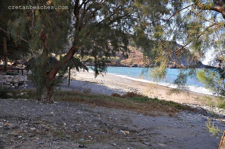
The enchanting beaches of Kissamos
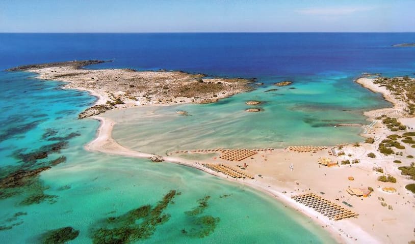
Elafonissi is located 76 kilometers southwest of Chania and five kilometers south of Chrysoskalitissa Monastery, at the southwest end of Crete. Elafonissi looks like an island, because the peninsula at the point that connects with Crete "breaks" and gives the feeling of a separate island.
The area has been included in the Natura Protected Areas and is a refuge for the Careta careta turtle. It is strictly forbidden to cut plants from there or to take sand even from the shore!
In Elafonissi you will get to the road from Kissamos in about an hour even by bus from KTEL. The road to Elafonissi is narrow and full of turns, but the beauty of the landscape will compensate for you. More choices for accommodation and food can be found in Chryssoskalitissa, located five kilometers north and there you will see the famous Monastery of Panagia Chrysoskalitissa.
The beach stretches over long stretches, mainly east of the lagoon. It is organized, it has everything (and special parking space) and especially during the summer months is flooded by people. The shallow lagoon is ideal for young but also for the grown-ups who are willing to play with sand and water!
At some points the color of the sand is not white but pink, which is created by the millions of broken shells you will see there.
The shores of Elafonisi are more remote and if you want to be a bit more isolated, walk until you find the cove that suits you. The tour of the island is easy to walk.
442 locals recommend
Elafonisi
Elafonissi is located 76 kilometers southwest of Chania and five kilometers south of Chrysoskalitissa Monastery, at the southwest end of Crete. Elafonissi looks like an island, because the peninsula at the point that connects with Crete "breaks" and gives the feeling of a separate island.
The area has been included in the Natura Protected Areas and is a refuge for the Careta careta turtle. It is strictly forbidden to cut plants from there or to take sand even from the shore!
In Elafonissi you will get to the road from Kissamos in about an hour even by bus from KTEL. The road to Elafonissi is narrow and full of turns, but the beauty of the landscape will compensate for you. More choices for accommodation and food can be found in Chryssoskalitissa, located five kilometers north and there you will see the famous Monastery of Panagia Chrysoskalitissa.
The beach stretches over long stretches, mainly east of the lagoon. It is organized, it has everything (and special parking space) and especially during the summer months is flooded by people. The shallow lagoon is ideal for young but also for the grown-ups who are willing to play with sand and water!
At some points the color of the sand is not white but pink, which is created by the millions of broken shells you will see there.
The shores of Elafonisi are more remote and if you want to be a bit more isolated, walk until you find the cove that suits you. The tour of the island is easy to walk.
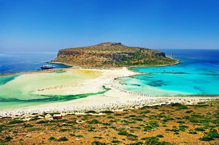
Balos is among the most beautiful beaches of Chania, but also the whole country. It is formed by a massive rock lying in the sea and connected to the land by a sandy peninsula, which creates a huge white sandy beach!
The shallow waters in the lagoon of Balos are either blue or turquoise. Everywhere there are small shells that in many places make the sand look pink ... The scattered rocks give a special touch to the scenery.
Balos is located in the northwest part of the Prefecture of Chania, at the Cape of Gramvousa, 17 km from Kissamos. Summer is always full of people, which mainly comes with a boat from Kissamos, since this is the easiest way to get there. But if you have a suitable car, you can follow the dirt road that starts from Kaliviani and reaches as far as the edge of the mountain above Ballos. The view of the stunning coast from above will fascinate you! From there you will need to descend the stone path to the beach. The downhill course is easy, but little will make you tired.
To reach Balos you can still walk the path from Kaliviani. It is a route to the wild Cretan landscape, about three hours long, for which you will definitely need a hat and water.
Otherwise, to visit Balos, you can board one of the day cruise boats, combine the beach with the islet of Gramvousa and its own lovely beach and depart from Kissamos.
The lagoon of Balos is part of the Natura program as it hosts rare species of flora and fauna such as the Caretta-Caretta sea turtles, cormorants, blackheads and crustaceans.
515 locals recommend
Balos Beach
Balos is among the most beautiful beaches of Chania, but also the whole country. It is formed by a massive rock lying in the sea and connected to the land by a sandy peninsula, which creates a huge white sandy beach!
The shallow waters in the lagoon of Balos are either blue or turquoise. Everywhere there are small shells that in many places make the sand look pink ... The scattered rocks give a special touch to the scenery.
Balos is located in the northwest part of the Prefecture of Chania, at the Cape of Gramvousa, 17 km from Kissamos. Summer is always full of people, which mainly comes with a boat from Kissamos, since this is the easiest way to get there. But if you have a suitable car, you can follow the dirt road that starts from Kaliviani and reaches as far as the edge of the mountain above Ballos. The view of the stunning coast from above will fascinate you! From there you will need to descend the stone path to the beach. The downhill course is easy, but little will make you tired.
To reach Balos you can still walk the path from Kaliviani. It is a route to the wild Cretan landscape, about three hours long, for which you will definitely need a hat and water.
Otherwise, to visit Balos, you can board one of the day cruise boats, combine the beach with the islet of Gramvousa and its own lovely beach and depart from Kissamos.
The lagoon of Balos is part of the Natura program as it hosts rare species of flora and fauna such as the Caretta-Caretta sea turtles, cormorants, blackheads and crustaceans.
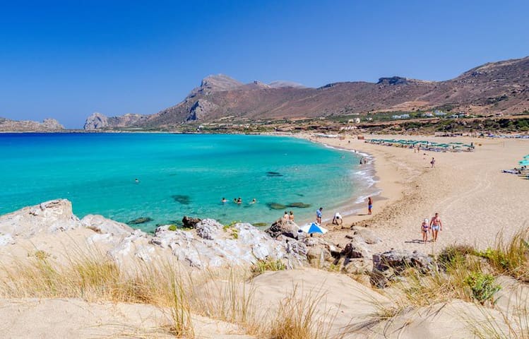
The beaches in Falasarna are not just exceptional, they are among those areas you should visit at least once in your life.
The Bay of Falasarna, with its crystal blue waters and white sand, surrounded by a verdant wild landscape, is 59 kilometers west of Chania and 17 kilometers west of Kissamos.
Falassarna has been awarded in the past as the best beach in Crete and one of the ten best in Europe. The coastline is very large in size and consists essentially of five successive beaches, of which the two most central are the most favorite for most.
The sand there is white and so the seawater gets tropical. The main beach of Falasarna is called Pahia Ammos and is an exotic wide sandy beach one kilometer long. Accepts most people in the area and there are umbrellas and refreshments where you can buy the necessary ones. There is also a beach volley court and water sports.
North of the central beach in Falassarna there is a second, long beach 800 meters long, almost the same as the central one, divided into smaller smaller beaches.
This beach is quieter than Pahia Ammos and is not organized. Nearby you will also see the chapel of Agia Paraskevi with a spring of fresh water that springs next to it.
At the northern end of the beach there are ruins of ancient Falassarna. There, next to the archaeological site, there is a small bay looking south. The shore has pebbles and its bottom is rocky.
Do not leave the beach before sunset as the sunset in Falassarna is magical, because the sun is lost in the sea as there is no physical obstacle on the horizon!
In the evening, you can also enjoy some of the many parties organized on the beach.
369 locals recommend
Phalasarna
The beaches in Falasarna are not just exceptional, they are among those areas you should visit at least once in your life.
The Bay of Falasarna, with its crystal blue waters and white sand, surrounded by a verdant wild landscape, is 59 kilometers west of Chania and 17 kilometers west of Kissamos.
Falassarna has been awarded in the past as the best beach in Crete and one of the ten best in Europe. The coastline is very large in size and consists essentially of five successive beaches, of which the two most central are the most favorite for most.
The sand there is white and so the seawater gets tropical. The main beach of Falasarna is called Pahia Ammos and is an exotic wide sandy beach one kilometer long. Accepts most people in the area and there are umbrellas and refreshments where you can buy the necessary ones. There is also a beach volley court and water sports.
North of the central beach in Falassarna there is a second, long beach 800 meters long, almost the same as the central one, divided into smaller smaller beaches.
This beach is quieter than Pahia Ammos and is not organized. Nearby you will also see the chapel of Agia Paraskevi with a spring of fresh water that springs next to it.
At the northern end of the beach there are ruins of ancient Falassarna. There, next to the archaeological site, there is a small bay looking south. The shore has pebbles and its bottom is rocky.
Do not leave the beach before sunset as the sunset in Falassarna is magical, because the sun is lost in the sea as there is no physical obstacle on the horizon!
In the evening, you can also enjoy some of the many parties organized on the beach.
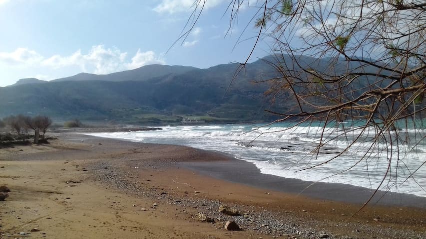
Viglia beach is located 4 kilometers west of the city of Kissamos and as all of Crete has a long history that is sealed with legends and traditions.
It offers peace and tranquility away from the noises of the big cities. in admixture with crystal clear waters. 1 kilometer before will met the trachilos beach in the relevant place, were found Human footprints 6 million years old. Cretan the "first" man.
7 locals recommend
Viglia Beach
Viglia beach is located 4 kilometers west of the city of Kissamos and as all of Crete has a long history that is sealed with legends and traditions.
It offers peace and tranquility away from the noises of the big cities. in admixture with crystal clear waters. 1 kilometer before will met the trachilos beach in the relevant place, were found Human footprints 6 million years old. Cretan the "first" man.
Sfinari is 60 km west of the city of Chania and 30 km south of Kissamos and is built at the exit of a green valley surrounded by the beautiful Koutrouli Mountain. It is one of the few beaches of the wild west coast of Crete that is worth visiting and is especially preferred by those who seek tranquility. Sfinari has a beautiful sandy beach with pebbles in some places, while the umbrellas are unnecessary as there are dozens of big trees. There are several accommodation and dining facilities in the area.
There are bus services for Sfinari from the long distance bus station of Chania and Kissamos.
It is worthwhile to walk on the steep uphill path that leads behind the rocky volume of Akrotiri Korakas, south of the beach. Besides the fantastic view, on the other side is a beautiful beach, Platanakia. With cautious downhill, you can enjoy your swim in it.
8 locals recommend
Sfinari
Sfinari is 60 km west of the city of Chania and 30 km south of Kissamos and is built at the exit of a green valley surrounded by the beautiful Koutrouli Mountain. It is one of the few beaches of the wild west coast of Crete that is worth visiting and is especially preferred by those who seek tranquility. Sfinari has a beautiful sandy beach with pebbles in some places, while the umbrellas are unnecessary as there are dozens of big trees. There are several accommodation and dining facilities in the area.
There are bus services for Sfinari from the long distance bus station of Chania and Kissamos.
It is worthwhile to walk on the steep uphill path that leads behind the rocky volume of Akrotiri Korakas, south of the beach. Besides the fantastic view, on the other side is a beautiful beach, Platanakia. With cautious downhill, you can enjoy your swim in it.
Paleochora is a seaside town of Chania and one of the premier summer resorts of the prefecture. It is located in the southwest of Chania, 77 km from the city. It has about 2,500 permanent residents. It is built on an elongated peninsula stretching across the Libyan Sea.
In Paleochora you will find small hotels, apartments and rooms to rent, as well as two organized campsites. The first camping is in Paleochora, on the east side of the Halikia beach, while the second is in Grammeno and is about four kilometers west of the city.
In Paleochora you will find many restaurants, taverns, cafes, bars, summer cinema, supermarkets, bakery, souvenir shops, bank, ATM, taxi, car rental and everything you need on your vacation.
Paleochora is the ideal choice for many activities during your holiday, ie swimming, surfing, fishing, diving, hiking. Its golden sandy beach gathers crowds of people.
From the port of Paleochora you can take the boat for all the beauties in southern Chania, Gavdos, Sougia, Agia Roumeli, Loutro and Sfakia.
185 locals recommend
Palaiochora
Paleochora is a seaside town of Chania and one of the premier summer resorts of the prefecture. It is located in the southwest of Chania, 77 km from the city. It has about 2,500 permanent residents. It is built on an elongated peninsula stretching across the Libyan Sea.
In Paleochora you will find small hotels, apartments and rooms to rent, as well as two organized campsites. The first camping is in Paleochora, on the east side of the Halikia beach, while the second is in Grammeno and is about four kilometers west of the city.
In Paleochora you will find many restaurants, taverns, cafes, bars, summer cinema, supermarkets, bakery, souvenir shops, bank, ATM, taxi, car rental and everything you need on your vacation.
Paleochora is the ideal choice for many activities during your holiday, ie swimming, surfing, fishing, diving, hiking. Its golden sandy beach gathers crowds of people.
From the port of Paleochora you can take the boat for all the beauties in southern Chania, Gavdos, Sougia, Agia Roumeli, Loutro and Sfakia.
A smaller but very nice beach in Falassarna ideal for families. Here the rocks in the sea create a shallow pool, protected from the wind. great for toddlers,
Baby Beach Falasarna
A smaller but very nice beach in Falassarna ideal for families. Here the rocks in the sea create a shallow pool, protected from the wind. great for toddlers,
The Elf Cave is located 70km southwest of the city of Chania, 30km south of Kissamos and 1.5km northwest of the village of Keramoti. The name of the beach comes from the small cave located next door, with the small church on the rock. It is a completely isolated rocky beach formed in a small bay north of Cape Koutoulos, in the middle of the wild West coast of Crete. There is no infrastructure in the area, making it ideal for a mask and for moments of seclusion.
Xotikospilio
The Elf Cave is located 70km southwest of the city of Chania, 30km south of Kissamos and 1.5km northwest of the village of Keramoti. The name of the beach comes from the small cave located next door, with the small church on the rock. It is a completely isolated rocky beach formed in a small bay north of Cape Koutoulos, in the middle of the wild West coast of Crete. There is no infrastructure in the area, making it ideal for a mask and for moments of seclusion.
Voulolimni is located about 70km southwest of Chania and 500m northwest of Chrysoskalitissa Monastery and near Elafonisi. It is a very special "crater" in the sea, surrounded by beautiful rocks and well protected from strong winds. Voulolimni is not actually a beach, but the small natural pool of the locals that in recent years has been loved by many nudists.
This natural harbor is sometimes used for mooring small boats, as there is a very narrow opening through which boats pass. The waters of the lake are always calm and with deep blue colors, which makes them very beautiful. Access is by dirt road from the settlement of Chrysoskalitissa and in the direction of the church of Agios Panteleimon, which is located very close.
Boulólimnē
Voulolimni is located about 70km southwest of Chania and 500m northwest of Chrysoskalitissa Monastery and near Elafonisi. It is a very special "crater" in the sea, surrounded by beautiful rocks and well protected from strong winds. Voulolimni is not actually a beach, but the small natural pool of the locals that in recent years has been loved by many nudists.
This natural harbor is sometimes used for mooring small boats, as there is a very narrow opening through which boats pass. The waters of the lake are always calm and with deep blue colors, which makes them very beautiful. Access is by dirt road from the settlement of Chrysoskalitissa and in the direction of the church of Agios Panteleimon, which is located very close.
The thousands of tourists who flock daily to the neighboring exotic Elafonissi are unaware of the existence of this small earthly paradise. It is a very small unorganized white sand beach, which is surrounded by many rocks that create a natural dam and a small protected lake.
7 locals recommend
White Lake beach
The thousands of tourists who flock daily to the neighboring exotic Elafonissi are unaware of the existence of this small earthly paradise. It is a very small unorganized white sand beach, which is surrounded by many rocks that create a natural dam and a small protected lake.
Kedrodasos Beach
Very beautiful place and not touristic.
Αξιοθέατα
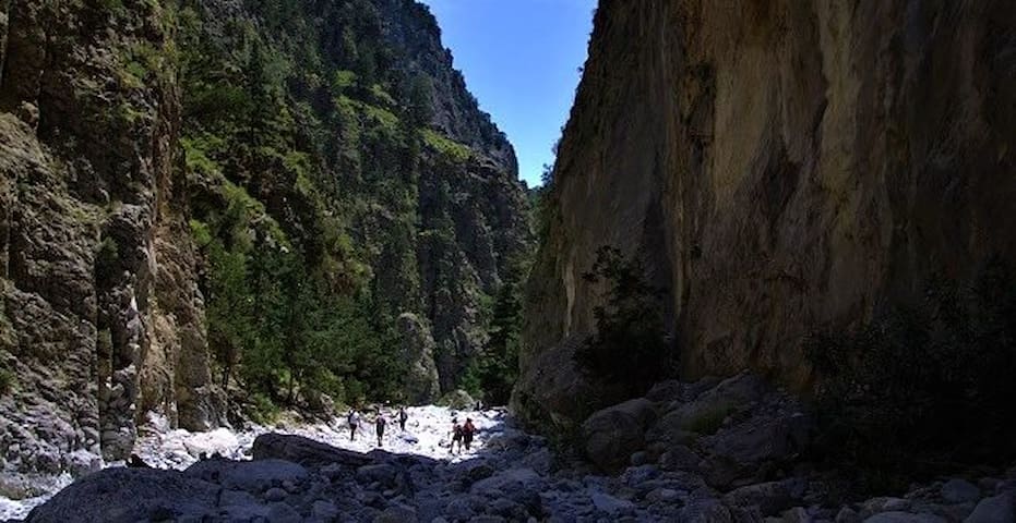
The Samaria Gorge is the largest in Greece and its crossing is the main purpose of the trip of many tourists arriving in Crete. Its 18 km stretch takes between 4 and 7 hours depending on the experience and the strength of the hikers.
The descent starts from the plateau of Omalos in the White Mountains and ends at the seaside village of Agia Roumeli in the south of the prefecture of Chania. The entrance is from the "Xyloskalo" area at 1,200 meters altitude.
To enter the gorge, cut a ticket at the National Park. The price is symbolic, but your ticket will be validated on your exit from the Samaria Gorge and in this way the count of those who entered will be counted against those who left.
The Samaria Gorge and a large area of about 48,500 acres around it have been designated as National Park, which joined the UNESCO World Biosphere Reserve Network in 2010.
There are the chickpeas of Crete, the Kri - Kri, but also many other species of animals that are not found anywhere else: Cretan ash (Cretan), Cretan ferret (sturgeon), Cretan anatomic, Cretan beetle (kalogianos). Gulls, golden eagles and vultures make up the forest fauna along with hundreds of other smaller bird species. More than 450 species of flora in the gorge, many of which are also unique in the world, so it is forbidden to cut the plants that you find on your way.
The Samaria Gorge was named after the small Byzantine temple located in the middle of it, built in 1379 and called Osia Maria. From this chapel was also named the village "Samaria", which was built next to it, and was abandoned by its permanent residents in 1962, with the proclamation of the National Park. Today it is used as a stop by the hikers and by the guards of the National Park.
It is estimated that the canyon formations (the main gorge "meets" much smaller during its journey) were created some 14 million years ago, when the geological shifts in the area ruptured the stone volumes.
The largest width of the Samaria gorge reaches 150 meters, while the narrowest point is the "Doors" - just before the exit - with a width of 3 meters. The rocks there reach a height of 600 meters and the landscape takes breath!
The gorge is green and verdant. The meadows alternate with forests with pine trees, cypresses, hollies and others.
Along the Samaria Gorge you will find 22 springs with drinking water. Caves, such as Demonospilios, and inaccessible peaks such as Melinda at 2,134 meters or Gigilos at 1,864 meters, define and isolate you from the rest of the world.
Space and time acquire other properties within the ancient gorge and so close contact with nature makes you review and "see things in another way".
Human intervention is distinct in various places, but it has been assimilated by the natural environment and is nowadays as important as the beauties of the earth. These are Byzantine chapels, Venetian forts, but also ruins of ancient cities and Early Christian tombs. Shortly before the exit, there are the ruins of old Agia Roumeli, another village abandoned by its inhabitants, to be rebuilt to the beach where the canyon ends.
Useful information for the visitor
The vast expanse of the Samaria Gorge and the enthusiasm of the hikers is the frequent cause that many "get out of the way" from the main trail, so they can not get it again, so caution is needed. You should always follow the markings.
The Samaria Gorge is usually open from April to October, depending on the weather. If you choose to cross it in the spring or autumn, you will avoid crowds.
In the summer, however, especially the peak periods of up to 3,000 people cross the Samaria Gorge on a daily basis. They usually start around 8:00 in the morning to reach Agia Roumeli in the afternoon, diving into the blue sea at the beach and taking the ferry to go to Sfakia or Paleohora. If you prefer a quieter downhill, start at noon and spend your night in the rooms of Agia Roumeli.
It is a good idea to enter the Samaria Gorge with lightly dressed footwear, with special hiking shoes (the famous mountaineering braids), bring with you a light meal and of course a hat and sunscreen. You will drink water from the springs of the gorge, which you will encounter very often along your path. There are also toilets on the way. The rules that you have to observe while in the Woods are inviolable and help to preserve it.
Guardians will come across very often, and will solve any questions, but they will help you in what you need.
Chania Police Station: 2821053333
Port Authority of Chora Sfakion: 2825091292
Shingles Museum: 2821067140
Samaria Forest Forest Service: 2821092287
Forest Prison of Samaria settlement: 28250 91276
517 locals recommend
Samaria Gorge
The Samaria Gorge is the largest in Greece and its crossing is the main purpose of the trip of many tourists arriving in Crete. Its 18 km stretch takes between 4 and 7 hours depending on the experience and the strength of the hikers.
The descent starts from the plateau of Omalos in the White Mountains and ends at the seaside village of Agia Roumeli in the south of the prefecture of Chania. The entrance is from the "Xyloskalo" area at 1,200 meters altitude.
To enter the gorge, cut a ticket at the National Park. The price is symbolic, but your ticket will be validated on your exit from the Samaria Gorge and in this way the count of those who entered will be counted against those who left.
The Samaria Gorge and a large area of about 48,500 acres around it have been designated as National Park, which joined the UNESCO World Biosphere Reserve Network in 2010.
There are the chickpeas of Crete, the Kri - Kri, but also many other species of animals that are not found anywhere else: Cretan ash (Cretan), Cretan ferret (sturgeon), Cretan anatomic, Cretan beetle (kalogianos). Gulls, golden eagles and vultures make up the forest fauna along with hundreds of other smaller bird species. More than 450 species of flora in the gorge, many of which are also unique in the world, so it is forbidden to cut the plants that you find on your way.
The Samaria Gorge was named after the small Byzantine temple located in the middle of it, built in 1379 and called Osia Maria. From this chapel was also named the village "Samaria", which was built next to it, and was abandoned by its permanent residents in 1962, with the proclamation of the National Park. Today it is used as a stop by the hikers and by the guards of the National Park.
It is estimated that the canyon formations (the main gorge "meets" much smaller during its journey) were created some 14 million years ago, when the geological shifts in the area ruptured the stone volumes.
The largest width of the Samaria gorge reaches 150 meters, while the narrowest point is the "Doors" - just before the exit - with a width of 3 meters. The rocks there reach a height of 600 meters and the landscape takes breath!
The gorge is green and verdant. The meadows alternate with forests with pine trees, cypresses, hollies and others.
Along the Samaria Gorge you will find 22 springs with drinking water. Caves, such as Demonospilios, and inaccessible peaks such as Melinda at 2,134 meters or Gigilos at 1,864 meters, define and isolate you from the rest of the world.
Space and time acquire other properties within the ancient gorge and so close contact with nature makes you review and "see things in another way".
Human intervention is distinct in various places, but it has been assimilated by the natural environment and is nowadays as important as the beauties of the earth. These are Byzantine chapels, Venetian forts, but also ruins of ancient cities and Early Christian tombs. Shortly before the exit, there are the ruins of old Agia Roumeli, another village abandoned by its inhabitants, to be rebuilt to the beach where the canyon ends.
Useful information for the visitor
The vast expanse of the Samaria Gorge and the enthusiasm of the hikers is the frequent cause that many "get out of the way" from the main trail, so they can not get it again, so caution is needed. You should always follow the markings.
The Samaria Gorge is usually open from April to October, depending on the weather. If you choose to cross it in the spring or autumn, you will avoid crowds.
In the summer, however, especially the peak periods of up to 3,000 people cross the Samaria Gorge on a daily basis. They usually start around 8:00 in the morning to reach Agia Roumeli in the afternoon, diving into the blue sea at the beach and taking the ferry to go to Sfakia or Paleohora. If you prefer a quieter downhill, start at noon and spend your night in the rooms of Agia Roumeli.
It is a good idea to enter the Samaria Gorge with lightly dressed footwear, with special hiking shoes (the famous mountaineering braids), bring with you a light meal and of course a hat and sunscreen. You will drink water from the springs of the gorge, which you will encounter very often along your path. There are also toilets on the way. The rules that you have to observe while in the Woods are inviolable and help to preserve it.
Guardians will come across very often, and will solve any questions, but they will help you in what you need.
Chania Police Station: 2821053333
Port Authority of Chora Sfakion: 2825091292
Shingles Museum: 2821067140
Samaria Forest Forest Service: 2821092287
Forest Prison of Samaria settlement: 28250 91276
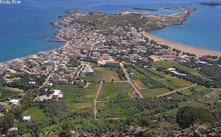
Ancient Kissamos, a coastal town on the northwest coast of Crete, has been identified for several centuries in the plain surrounding the Kissamos Bay. This ancient city was the harbor of ancient Polyrinia, the oldest Doric city of Crete, 7 km south of Kissamos, a naval and commercial center of the area. After the Roman conquest of Crete (in 69 BC), Kissamos experienced great economic and residential development.
Pliny (4,12,59) as Kissam is placed near Pergamon and Kydonia, while Ieroklis (Synod 14) between Kydonia and Kantanos. The "Kissamos polis" [5], as Ptolemy (3, 17, 8) mentions, is located in the present bay of Kissamos, in the surviving ruins near Kastelli (Venetian fortress).
It was close to the large town of Polyreninia, which was a seaport, but it operated as an autonomous community and cut its own coins depicting on one side the head of Hermes goddess with a petta and the other a dolphin and the letters ΚΣ / ΙΩ.
During the Venetian occupation, because of its wealth and location, Kissamos was well-fortified. The walls of the city were originated by the Venetians, (good ones) and parts of them still survive, west of the Turkish fortress. It was named "Kastelli" because of its fortress and in particular Kastelli Kissamou to avoid confusion, as Crete had a lot of Kastelias.
109 locals recommend
Kissamos
Ancient Kissamos, a coastal town on the northwest coast of Crete, has been identified for several centuries in the plain surrounding the Kissamos Bay. This ancient city was the harbor of ancient Polyrinia, the oldest Doric city of Crete, 7 km south of Kissamos, a naval and commercial center of the area. After the Roman conquest of Crete (in 69 BC), Kissamos experienced great economic and residential development.
Pliny (4,12,59) as Kissam is placed near Pergamon and Kydonia, while Ieroklis (Synod 14) between Kydonia and Kantanos. The "Kissamos polis" [5], as Ptolemy (3, 17, 8) mentions, is located in the present bay of Kissamos, in the surviving ruins near Kastelli (Venetian fortress).
It was close to the large town of Polyreninia, which was a seaport, but it operated as an autonomous community and cut its own coins depicting on one side the head of Hermes goddess with a petta and the other a dolphin and the letters ΚΣ / ΙΩ.
During the Venetian occupation, because of its wealth and location, Kissamos was well-fortified. The walls of the city were originated by the Venetians, (good ones) and parts of them still survive, west of the Turkish fortress. It was named "Kastelli" because of its fortress and in particular Kastelli Kissamou to avoid confusion, as Crete had a lot of Kastelias.
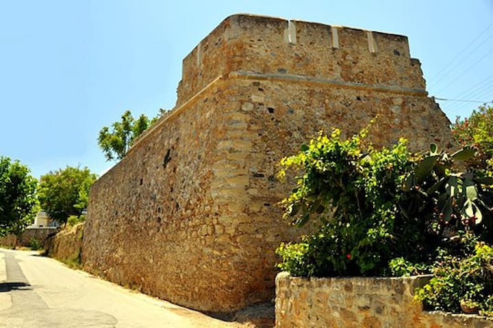
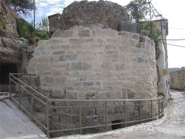
Polirinia was an ancient city and a Byzantine fortress. A part of the walls is preserved from the Hellenistic and Roman periods, but most of the fortifications are medieval.
Their dating has not been done with precision. It is probable that most of the Byzantine fortifications come from the 2nd Byzantine period (10th to 12th centuries).
The problem is that although there must have been a great city and fortress, there are no reports of medieval sources.
There is also a case of earlier researchers that the fortification was strengthened during the Venetian period, but that is probably not the case, as there is no evidence of interventions at that time in the area.
Location & Strategic Importance
Polirinia is located south of Kasteli Kissamos at a distance of 4 km, on a hill near 400 meters high. The ruins of the city cover an area of 350 acres and are located on the slopes of the hill and on the upper plateau.
The location has a splendid view to the whole bay of Kissamos, also to the east passes between the hills from where the artery from Chania to the plain of Kissamos passes.
To the south it faces the entire Kissamos hinterland and to the south the Libyan Sea. To the south and east, it has a visual contact with the nearby castle of Malathyros and the east with the fortress of Rokas.
Structural, Architectural, Fortification
The medieval fortification does not use the earlier engraving of the fortification enclosure, but a more limited perimeter. Perhaps it is a sign of shrinking the settlement. Only the area of the acropolis is used by the ancient fortification.
The outer courtyard and the towers of the Byzantine fortification have a uniform shape. Their masonry includes claystone made of gray local limestone with strong plaster and coumaran as binder. Interstitial bricks are interposed, while several stoneworks are embedded in the oldest walls.
The wall is preserved at a maximum height of 3.5 meters with a perimeter 1.30m wide. and a parapet of 0.50m. The western wall ascends to the south following the curves of the ground with a width of 2.60m. On the eastern wall there are traces of a narrow gate that was housed with a large monolith lintel. In the midst of the walled space we find ruins of buildings, and some of them have been converted into a temple that is now ruined.
Towards the south stands the Acropolis, which is surrounded by an enclosure of the same construction and 2 m thick. To the north we see the entire western fortification enclosure. It is the point where a narrow wall starts westward and leads to a large horseshoe tower lower than the level of the enclosure, which scans and controls the entire western slope outside the castle. Internally, it is empty (today admired) and is in a relatively good condition.
At some point in the southern courtyard near the larger acropolis, a semicircular tower is half-ruined. The wall descends to the south following the slope of the ground to the southern edge where the cliff begins. There he joins and identifies himself with the oldest wall.
The current settlement of Polirinia (formerly Paliokastro) is aged for many centuries but is later of the castle. It is indicative that his tallest neighborhood has occupied a section of the ancient city to the south of the hill. All the houses of the settlement have incorporated ancient members, mainly square squares like those that are still visible in the oldest walls.
The whole fortification has clear elements of Byzantine fortifications: briquettes, tarsus with tarraun, perimeter and wall-hanging, cast masonry, semicircular towers, escape pillars and cisterns painted.
The whole construction is a serious and costly fortification project with monumental dimensions and it is amazing that there is no more information about it.
29 locals recommend
Polyrrhenia
Polirinia was an ancient city and a Byzantine fortress. A part of the walls is preserved from the Hellenistic and Roman periods, but most of the fortifications are medieval.
Their dating has not been done with precision. It is probable that most of the Byzantine fortifications come from the 2nd Byzantine period (10th to 12th centuries).
The problem is that although there must have been a great city and fortress, there are no reports of medieval sources.
There is also a case of earlier researchers that the fortification was strengthened during the Venetian period, but that is probably not the case, as there is no evidence of interventions at that time in the area.
Location & Strategic Importance
Polirinia is located south of Kasteli Kissamos at a distance of 4 km, on a hill near 400 meters high. The ruins of the city cover an area of 350 acres and are located on the slopes of the hill and on the upper plateau.
The location has a splendid view to the whole bay of Kissamos, also to the east passes between the hills from where the artery from Chania to the plain of Kissamos passes.
To the south it faces the entire Kissamos hinterland and to the south the Libyan Sea. To the south and east, it has a visual contact with the nearby castle of Malathyros and the east with the fortress of Rokas.
Structural, Architectural, Fortification
The medieval fortification does not use the earlier engraving of the fortification enclosure, but a more limited perimeter. Perhaps it is a sign of shrinking the settlement. Only the area of the acropolis is used by the ancient fortification.
The outer courtyard and the towers of the Byzantine fortification have a uniform shape. Their masonry includes claystone made of gray local limestone with strong plaster and coumaran as binder. Interstitial bricks are interposed, while several stoneworks are embedded in the oldest walls.
The wall is preserved at a maximum height of 3.5 meters with a perimeter 1.30m wide. and a parapet of 0.50m. The western wall ascends to the south following the curves of the ground with a width of 2.60m. On the eastern wall there are traces of a narrow gate that was housed with a large monolith lintel. In the midst of the walled space we find ruins of buildings, and some of them have been converted into a temple that is now ruined.
Towards the south stands the Acropolis, which is surrounded by an enclosure of the same construction and 2 m thick. To the north we see the entire western fortification enclosure. It is the point where a narrow wall starts westward and leads to a large horseshoe tower lower than the level of the enclosure, which scans and controls the entire western slope outside the castle. Internally, it is empty (today admired) and is in a relatively good condition.
At some point in the southern courtyard near the larger acropolis, a semicircular tower is half-ruined. The wall descends to the south following the slope of the ground to the southern edge where the cliff begins. There he joins and identifies himself with the oldest wall.
The current settlement of Polirinia (formerly Paliokastro) is aged for many centuries but is later of the castle. It is indicative that his tallest neighborhood has occupied a section of the ancient city to the south of the hill. All the houses of the settlement have incorporated ancient members, mainly square squares like those that are still visible in the oldest walls.
The whole fortification has clear elements of Byzantine fortifications: briquettes, tarsus with tarraun, perimeter and wall-hanging, cast masonry, semicircular towers, escape pillars and cisterns painted.
The whole construction is a serious and costly fortification project with monumental dimensions and it is amazing that there is no more information about it.
Lake Kournas is the only freshwater lake in Crete. Lake Kurna in ancient times was known as Korissia, but later took its present name from the Arabic word for lake.
It is in a very beautiful location, in a pit between the hills, about 4km from Georgioupolis in the prefecture of Chania (western Crete).
Lake Kournas is relatively small with a maximum length of 1087 meters and a maximum width of 880 meters. It covers an area of 579 hectares and is generally shallow with a depth of 22.5 meters and is about 20 meters higher than the sea.
Lake Kournas is an ideal destination for an afternoon stroll, or a day trip. Many also prefer it for an afternoon picnic. The scenery is relaxing and beautiful, whether you want to walk in the nature, swim or bike in the lake.
At Lake Kournas there are two springs on the South East Coast, one of which is visible at the end of summer, the Eye or the Amati, as the locals call it. The lake is fed by the waters coming down from the neighboring mountains and hills, which cut off the rocks of the area and prevent them from continuing their course to the sea.
361 locals recommend
Lake Kournas
Lake Kournas is the only freshwater lake in Crete. Lake Kurna in ancient times was known as Korissia, but later took its present name from the Arabic word for lake.
It is in a very beautiful location, in a pit between the hills, about 4km from Georgioupolis in the prefecture of Chania (western Crete).
Lake Kournas is relatively small with a maximum length of 1087 meters and a maximum width of 880 meters. It covers an area of 579 hectares and is generally shallow with a depth of 22.5 meters and is about 20 meters higher than the sea.
Lake Kournas is an ideal destination for an afternoon stroll, or a day trip. Many also prefer it for an afternoon picnic. The scenery is relaxing and beautiful, whether you want to walk in the nature, swim or bike in the lake.
At Lake Kournas there are two springs on the South East Coast, one of which is visible at the end of summer, the Eye or the Amati, as the locals call it. The lake is fed by the waters coming down from the neighboring mountains and hills, which cut off the rocks of the area and prevent them from continuing their course to the sea.
The old town of Chania is located next to the old port of the city. In the past the old city was surrounded by the Venetian walls, today their left and right parts have been saved, but not the southern one. Most of the buildings in the area are old but are in good condition, the alleys are small and picturesque so the old town is the ideal environment for endless walks. Especially the old Venetian port is an oasis of beauty. There you will find small shops to buy your souvenirs, cafes and many taverns to enjoy your nights in an idyllic setting.
399 locals recommend
Old Venetian Harbor
8 Agiou MarkouThe old town of Chania is located next to the old port of the city. In the past the old city was surrounded by the Venetian walls, today their left and right parts have been saved, but not the southern one. Most of the buildings in the area are old but are in good condition, the alleys are small and picturesque so the old town is the ideal environment for endless walks. Especially the old Venetian port is an oasis of beauty. There you will find small shops to buy your souvenirs, cafes and many taverns to enjoy your nights in an idyllic setting.