
Discover the East coast of Greece - Preveza
Αξιοθέατα
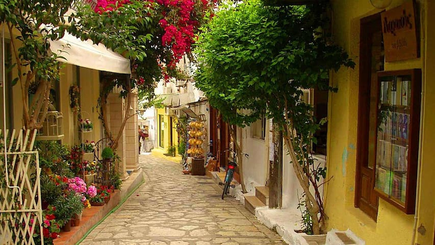
Arriving by land, sea or air, Preveza welcomes you and smiles at you. Where the clear blue Ionian and the calm Amvrakikos meet, the city-island of three castles, with a wonderful waterfront, a marina full of sailboats, dozens of restaurants and taverns, pedestrian streets and a historic center with refined shops, will charm you. Just outside the city, in ancient Nicopolis, we "meet" Octavian Augustus, Antony and Cleopatra. Then we start the engine and prepare to explore the 60 kilometers of beaches. In this corner of Epirus, the choices are endless and neither are the pleasures...
Preveza! So beautiful, you want to stay here forever❤
48 locals recommend
Preveza
Arriving by land, sea or air, Preveza welcomes you and smiles at you. Where the clear blue Ionian and the calm Amvrakikos meet, the city-island of three castles, with a wonderful waterfront, a marina full of sailboats, dozens of restaurants and taverns, pedestrian streets and a historic center with refined shops, will charm you. Just outside the city, in ancient Nicopolis, we "meet" Octavian Augustus, Antony and Cleopatra. Then we start the engine and prepare to explore the 60 kilometers of beaches. In this corner of Epirus, the choices are endless and neither are the pleasures...
Preveza! So beautiful, you want to stay here forever❤
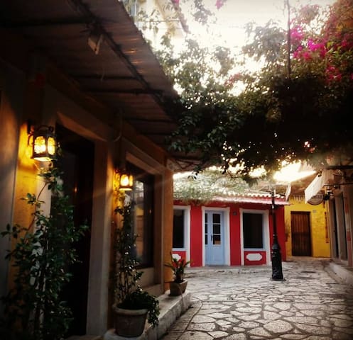
In the heart of the city you get to know the area of ''Shaitan Pazar''
The myth of the gunpowder Turk:
Since the story of Shaitan Pazar begins in the Ottoman Empire, from a Turkish military commander who was cruel and violent, you must follow the pulse of the fun by exorcising the old curse of that gunpowder Turkish master. In order to treat him as he deserved, the legend again wants the inhabitants of the street to have soaped the stone pavement, where it had a steep slope, one night. When, the next morning, the Turkish commander rode his horse through Shaitan Pazar, the horse slipped and he fell down, shouting: "Shaitan Pazar." Today, the phrase has been written into the oral history of the city of Preveza to give it another cute feature that distinguishes it.
In this authentic natural setting of Preveza and the mainland, you can walk for hours, looking at beautiful trifles. Here is also the house on Dardanelion Street, where the poet Karyotakis lived his last days. At the junction of Kontos and Ethniki Antistanis streets, see the famous church of Agios Charalambos who is the patron saint of Preveza and distinguish the details, the impressive Venetian tower and the sundial. Honor the traditional flavors of the region, feta and pies, local grilled meats and seafood. Wonderful shops all around, in every direction, engraved with centuries of history, keep you entertained until the early hours of the morning.
14 locals recommend
Saitan Bazaar - Σαϊτάν Παζάρ
5 Christou KontouIn the heart of the city you get to know the area of ''Shaitan Pazar''
The myth of the gunpowder Turk:
Since the story of Shaitan Pazar begins in the Ottoman Empire, from a Turkish military commander who was cruel and violent, you must follow the pulse of the fun by exorcising the old curse of that gunpowder Turkish master. In order to treat him as he deserved, the legend again wants the inhabitants of the street to have soaped the stone pavement, where it had a steep slope, one night. When, the next morning, the Turkish commander rode his horse through Shaitan Pazar, the horse slipped and he fell down, shouting: "Shaitan Pazar." Today, the phrase has been written into the oral history of the city of Preveza to give it another cute feature that distinguishes it.
In this authentic natural setting of Preveza and the mainland, you can walk for hours, looking at beautiful trifles. Here is also the house on Dardanelion Street, where the poet Karyotakis lived his last days. At the junction of Kontos and Ethniki Antistanis streets, see the famous church of Agios Charalambos who is the patron saint of Preveza and distinguish the details, the impressive Venetian tower and the sundial. Honor the traditional flavors of the region, feta and pies, local grilled meats and seafood. Wonderful shops all around, in every direction, engraved with centuries of history, keep you entertained until the early hours of the morning.
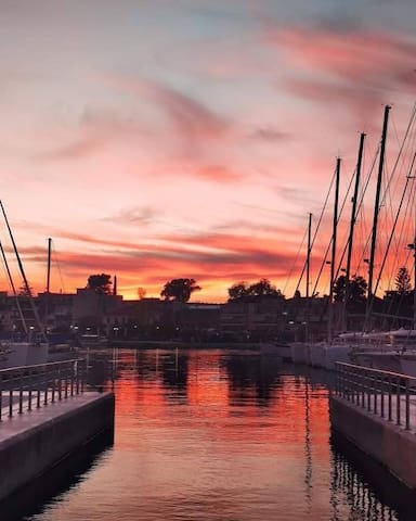
The marina of preveza is one of the most well organised and modern marinas in Greece
Preveza Marina is located at the Port of Preveza, inside of Amvrakikos Gulf at the heart of the Ionian Sea
48 locals recommend
Preveza
The marina of preveza is one of the most well organised and modern marinas in Greece
Preveza Marina is located at the Port of Preveza, inside of Amvrakikos Gulf at the heart of the Ionian Sea
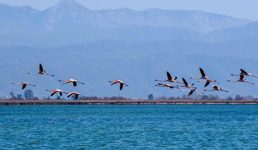
Amvrakikos gulf, dancing with the dolphins...
The Amvrakikos Gulf is one of the largest wetlands in Greece both in terms of size and importance. An ecosystem with great aesthetic and ecological value. The Gulf occupies an area of about 400 km and is an enclosed sea, which includes many smaller wetlands. The rivers Louros and Arachthos flow into Amvrakikos, carrying their abundant waters and significant quantities of transported materials, contributing to the formation of an extremely complex and unique for Greek data, wetland system.
Amvrakikos communicates with the Ionian Sea through the strait of Preveza.
There are daily tours based on dolphin and wildlife observation
Enjoy a unique and authentic Greek experience in the Amvrakikos gulf.
Ambracian Gulf, Greece
Amvrakikos gulf, dancing with the dolphins...
The Amvrakikos Gulf is one of the largest wetlands in Greece both in terms of size and importance. An ecosystem with great aesthetic and ecological value. The Gulf occupies an area of about 400 km and is an enclosed sea, which includes many smaller wetlands. The rivers Louros and Arachthos flow into Amvrakikos, carrying their abundant waters and significant quantities of transported materials, contributing to the formation of an extremely complex and unique for Greek data, wetland system.
Amvrakikos communicates with the Ionian Sea through the strait of Preveza.
There are daily tours based on dolphin and wildlife observation
Enjoy a unique and authentic Greek experience in the Amvrakikos gulf.
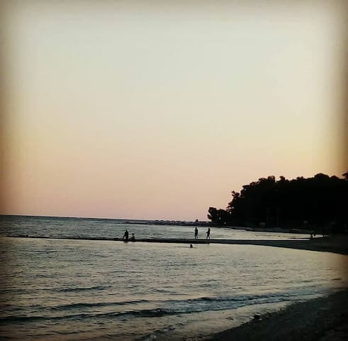
A lovely beach with bars, cafes and restaurants very close to the city center and only 1,5 km from the apartment.
The beach is located at the entrance of Amvrakikos gulf and very close to the center of Preveza. It is a beach with shallow waters and fine sand, just a few meters from the city's paved beach, which makes it easily accessible on foot.
One of the oldest organized beaches in the area, which is surrounded by a beautiful grove. A fact that makes it unique in its kind, right at the "mouth" where the Amvrakikos Gulf meets the Ionian Sea, with a view of the planes that transport visitors to the nearby airport.
On the Blue Coast, in addition to a swim, one can enjoy a sports activity (swimming pool, basketball, tennis) in the nearby sports complex, a walk in nature, but also watch the traditional ambali, a sport of the old Prevezans that is being revived nowadays.
Beach with shallow water and fine sand
Blue flag, lifeguard and showers
Ideal for children
Special wheelchair for disabled access
Beach Bar with free sunbeds
Easily accessible on foot, as it is only 1.2 kilometers from the city center
20 locals recommend
Blue Coast
Αγίου ΓεωργίουA lovely beach with bars, cafes and restaurants very close to the city center and only 1,5 km from the apartment.
The beach is located at the entrance of Amvrakikos gulf and very close to the center of Preveza. It is a beach with shallow waters and fine sand, just a few meters from the city's paved beach, which makes it easily accessible on foot.
One of the oldest organized beaches in the area, which is surrounded by a beautiful grove. A fact that makes it unique in its kind, right at the "mouth" where the Amvrakikos Gulf meets the Ionian Sea, with a view of the planes that transport visitors to the nearby airport.
On the Blue Coast, in addition to a swim, one can enjoy a sports activity (swimming pool, basketball, tennis) in the nearby sports complex, a walk in nature, but also watch the traditional ambali, a sport of the old Prevezans that is being revived nowadays.
Beach with shallow water and fine sand
Blue flag, lifeguard and showers
Ideal for children
Special wheelchair for disabled access
Beach Bar with free sunbeds
Easily accessible on foot, as it is only 1.2 kilometers from the city center
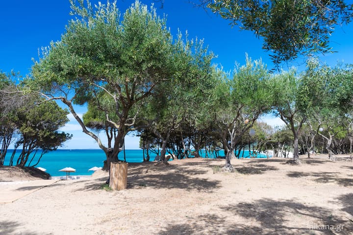
The largest beach in Europe!!!
The beach-jewel that is a trademark for Preveza. One of the unique areas in the Balkans that so harmoniously combines green and blue.
It is a sandy beach ideal for lovers of pebble beaches and deep crystal waters.
It extends over an area of tens of kilometers, which makes it claim the title of the longest sandy beach in the European Union.
Its visitor can visually enjoy either the deep blue of the Ionian Sea, facing Paxos in the distance or the deep green of the aesthetic forest (marked since 1977) of 660 acres, which offers the possibility for a wellness walk.
Pebble beach and deep water
Blue flag, lifeguards and showers
There are beach bars along the entire length with free sunbeds
Free parking
Accessible by car and with the urban KTEL routes in the summer months
Near the archaeological site of Ancient Nikopolis
10 kilometers from the center of Preveza
28 locals recommend
Monolithi Beach
The largest beach in Europe!!!
The beach-jewel that is a trademark for Preveza. One of the unique areas in the Balkans that so harmoniously combines green and blue.
It is a sandy beach ideal for lovers of pebble beaches and deep crystal waters.
It extends over an area of tens of kilometers, which makes it claim the title of the longest sandy beach in the European Union.
Its visitor can visually enjoy either the deep blue of the Ionian Sea, facing Paxos in the distance or the deep green of the aesthetic forest (marked since 1977) of 660 acres, which offers the possibility for a wellness walk.
Pebble beach and deep water
Blue flag, lifeguards and showers
There are beach bars along the entire length with free sunbeds
Free parking
Accessible by car and with the urban KTEL routes in the summer months
Near the archaeological site of Ancient Nikopolis
10 kilometers from the center of Preveza
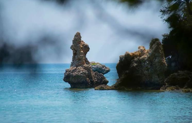
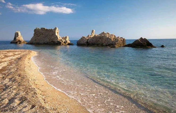
Τhe bay where Odysseus rested before reaching Ithaca
Perhaps the most picturesque beach of the Prefecture of Preveza.
"Hidden" in small streets that lead you to the one from the village of Valanidorachi and through a pine forest, a small beautiful creek emerges with a huge rock in the middle.
The crystal clear waters of the bay and its "mysticity" made it a place of special importance during World War II.
The small caves that have been formed and the beautiful landscape make Alonaki a must for those who want to visit the beaches of N. Preveza.
9 locals recommend
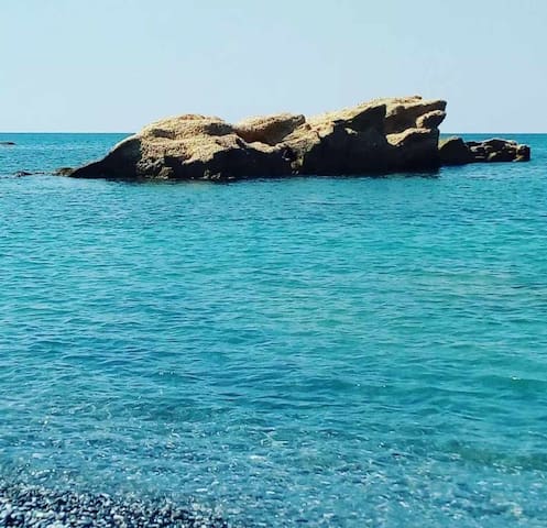
Kerentza Beach
Τhe bay where Odysseus rested before reaching Ithaca
Perhaps the most picturesque beach of the Prefecture of Preveza.
"Hidden" in small streets that lead you to the one from the village of Valanidorachi and through a pine forest, a small beautiful creek emerges with a huge rock in the middle.
The crystal clear waters of the bay and its "mysticity" made it a place of special importance during World War II.
The small caves that have been formed and the beautiful landscape make Alonaki a must for those who want to visit the beaches of N. Preveza.
Ideal for those who don't want crowded beaches.
Nature itself takes care to "hide" it so that it remains pristine, secluded and beautiful, preserving the mystery of the large rocks that stand in its blue waters.
Nearby you can enjoy fresh Ionian fish in the picturesque taverns.
Beach with fine sand, pebbles, rocky bottom and waters that deepen smoothly
There is no organized beach, sunbeds, umbrellas
There are no beach bar facilities nearby
Free parking
Easily accessible by car
27 kilometers from the center of Preveza
Paralia Artolithia, Zaloggo 481 00, Greece
Ideal for those who don't want crowded beaches.
Nature itself takes care to "hide" it so that it remains pristine, secluded and beautiful, preserving the mystery of the large rocks that stand in its blue waters.
Nearby you can enjoy fresh Ionian fish in the picturesque taverns.
Beach with fine sand, pebbles, rocky bottom and waters that deepen smoothly
There is no organized beach, sunbeds, umbrellas
There are no beach bar facilities nearby
Free parking
Easily accessible by car
27 kilometers from the center of Preveza
Lefka is located 22 km from Preveza, between Kastrosykia and Artolithia. It is ideal for those looking for beautiful destinations with tranquility, away from crowds and excessive tourism. It is an endless sandy beach of incomparable natural beauty that looks like a true miracle of nature!
It consists of fine all-white sand, in places pebbles and blue-green crystal clear waters. The coast is "embraced" by lush green bushes that contribute to the magical setting. The beach is not very shallow, however, it deepens smoothly. It is not organized, however you will find beach bars, restaurants and hotels nearby. It is easily accessible by car and you will not encounter any difficulty in parking.
Παραλία Λεύκα, Ζάλογγο 481 00, Greece
Lefka is located 22 km from Preveza, between Kastrosykia and Artolithia. It is ideal for those looking for beautiful destinations with tranquility, away from crowds and excessive tourism. It is an endless sandy beach of incomparable natural beauty that looks like a true miracle of nature!
It consists of fine all-white sand, in places pebbles and blue-green crystal clear waters. The coast is "embraced" by lush green bushes that contribute to the magical setting. The beach is not very shallow, however, it deepens smoothly. It is not organized, however you will find beach bars, restaurants and hotels nearby. It is easily accessible by car and you will not encounter any difficulty in parking.
The first beach of Preveza that was an organized beach for visitors to the area.
Its shallow waters and the light breeze that often prevails on the beach, make it an ideal destination for those who like activities with a board or a small sail in the sea.
The amphitheater configuration of the beach gives the visitor a beautiful view of the coastal zone of N. Preveza and Paxos opposite, when the horizon "clears", as well as a beautiful sunset in the evening hours.
Καστροσυκιά Πρέβεζας
The first beach of Preveza that was an organized beach for visitors to the area.
Its shallow waters and the light breeze that often prevails on the beach, make it an ideal destination for those who like activities with a board or a small sail in the sea.
The amphitheater configuration of the beach gives the visitor a beautiful view of the coastal zone of N. Preveza and Paxos opposite, when the horizon "clears", as well as a beautiful sunset in the evening hours.
A beach that is considered one of the hot destinations for Greek and foreign visitors to the area.
It stands out as an endless single beach with kilometers of fine sand, in a wooded landscape, while a few meters away there are organized high-level tourism services.
A busy beach in the summer months, which is a hub of entertainment from morning to night.
The Rock-Vrachos preveza!!!
A beach that is considered one of the hot destinations for Greek and foreign visitors to the area.
It stands out as an endless single beach with kilometers of fine sand, in a wooded landscape, while a few meters away there are organized high-level tourism services.
A busy beach in the summer months, which is a hub of entertainment from morning to night.
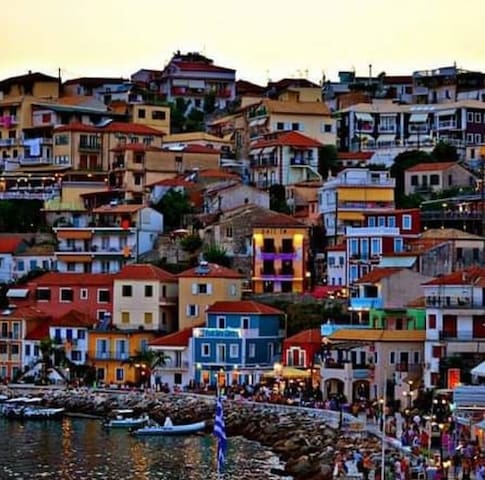
Parga is the most beautiful village in Preveza, and one of the most beautiful villages in Greece.
It is a beautiful traditional built-up area, amphitheatrically built in the fringes of the Venetian castle with a history of many centuries and a lot of natural beauties.
Narrow paving streets rising to the castle hill, the verdurous islet of the Virgin with its scenic country church, tasteful two and three-storey houses with wooden balconies and tiled roofs in accordance with the local popular architecture, are some of the lovely scenes the visitor meets in Parga.
67 locals recommend
Parga
Parga is the most beautiful village in Preveza, and one of the most beautiful villages in Greece.
It is a beautiful traditional built-up area, amphitheatrically built in the fringes of the Venetian castle with a history of many centuries and a lot of natural beauties.
Narrow paving streets rising to the castle hill, the verdurous islet of the Virgin with its scenic country church, tasteful two and three-storey houses with wooden balconies and tiled roofs in accordance with the local popular architecture, are some of the lovely scenes the visitor meets in Parga.
Acheron river. The river that led to Hades...
According to mythology, the Acheron plain was a place occupied by the souls of the dead. Charon led the souls via the River Acheron to Lake Acherousia, at the depths of which lay the kingdom of Hades. For this reason, the Acheron Necromanteion was established on the north eastern shore of Lake Acherousia, above a cave at the juncture of the Rivers Acheron and Cocytus. At this impressive site, people worshipped the gods of the Underworld and communicated with the souls of the dead. After being subjected to many days of preparation, including complete isolation and eating only certain foods, visitors were led into the underground chambers of the Necromanteion, where they communicated with the spirits of their dead loved ones who could predict the future. The area was an important destination for visitors, but its prosperity ended in 167 BC when the Roman Aemilius Paulus completely destroyed all the cities of Epirus, taking with him more than 150,000 prisoners. As the years passed, successive conquerors, constant wars and raiding missions resulted in the wider region of Acheron, and all of Epirus, falling into decline for a long period of time.
57 locals recommend
Acherontas
Acheron river. The river that led to Hades...
According to mythology, the Acheron plain was a place occupied by the souls of the dead. Charon led the souls via the River Acheron to Lake Acherousia, at the depths of which lay the kingdom of Hades. For this reason, the Acheron Necromanteion was established on the north eastern shore of Lake Acherousia, above a cave at the juncture of the Rivers Acheron and Cocytus. At this impressive site, people worshipped the gods of the Underworld and communicated with the souls of the dead. After being subjected to many days of preparation, including complete isolation and eating only certain foods, visitors were led into the underground chambers of the Necromanteion, where they communicated with the spirits of their dead loved ones who could predict the future. The area was an important destination for visitors, but its prosperity ended in 167 BC when the Roman Aemilius Paulus completely destroyed all the cities of Epirus, taking with him more than 150,000 prisoners. As the years passed, successive conquerors, constant wars and raiding missions resulted in the wider region of Acheron, and all of Epirus, falling into decline for a long period of time.
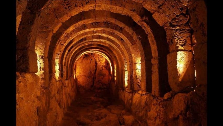
The most famous necromancy of the ancient Greek world is located near the northwestern shores of Lake Acherousia, at the point where the rivers of Hades, the Acheron and the Cokytos, meet.
The Nekromanteio in the village of Mesopotamos in the municipal unit of Fanario of the Municipality of Parga is a world famous monument for how the Ancients dealt with death. A monument depicting the legend of the descent of the dead into Hades, the Underworld, via the river Acheron and the world's most famous boatman, a process that gave Acheron worldwide fame through painting, literature, sculpture, poetry .
The faithful flocked to the Nekromanteio to get in touch with friends and relatives who are not in life through a mystical process.
The Necromanteion is located on the shores of the dried up lake of Acherousia, "overlooking" the plain of Fanarios at the point where the rivers Acheron and Kokytos meet. It is built on top of a hill and has a polygonal shape. It is a complex of buildings and facilities, multi-level, which enhances the myth of Necromanteion, having impressive acoustics in some parts of it.
In the area there are findings of anthropogenic activity dating back to the 13th-14th century BC. The remains of the Necromanteion that are preserved today are placed in the early Hellenistic times (end of the 4th - beginning of the 3rd century BC). The most recent intervention in the area took place in the 18th century with the construction of I.M. Of Saint John the Forerunner.
Useful infor
Nekromanteio is 42 km away. from the city of Preveza via E.O. Preveza-Igoumenitsa (place Mesopotamos), 9 km from Kanalaki (headquarters of the Municipality of Parga) and 20 km. from the city of Parga.
In the village of Mesopotamos there are restaurants and cafes, as well as a pharmacy.
At a distance of one kilometer are the remains of the ancient city of Ephyra.
You can combine your visit with a swim at Alonaki Fanario beach, which is only 5 km away.
37 locals recommend
Nekromanteion Acheron
The most famous necromancy of the ancient Greek world is located near the northwestern shores of Lake Acherousia, at the point where the rivers of Hades, the Acheron and the Cokytos, meet.
The Nekromanteio in the village of Mesopotamos in the municipal unit of Fanario of the Municipality of Parga is a world famous monument for how the Ancients dealt with death. A monument depicting the legend of the descent of the dead into Hades, the Underworld, via the river Acheron and the world's most famous boatman, a process that gave Acheron worldwide fame through painting, literature, sculpture, poetry .
The faithful flocked to the Nekromanteio to get in touch with friends and relatives who are not in life through a mystical process.
The Necromanteion is located on the shores of the dried up lake of Acherousia, "overlooking" the plain of Fanarios at the point where the rivers Acheron and Kokytos meet. It is built on top of a hill and has a polygonal shape. It is a complex of buildings and facilities, multi-level, which enhances the myth of Necromanteion, having impressive acoustics in some parts of it.
In the area there are findings of anthropogenic activity dating back to the 13th-14th century BC. The remains of the Necromanteion that are preserved today are placed in the early Hellenistic times (end of the 4th - beginning of the 3rd century BC). The most recent intervention in the area took place in the 18th century with the construction of I.M. Of Saint John the Forerunner.
Useful infor
Nekromanteio is 42 km away. from the city of Preveza via E.O. Preveza-Igoumenitsa (place Mesopotamos), 9 km from Kanalaki (headquarters of the Municipality of Parga) and 20 km. from the city of Parga.
In the village of Mesopotamos there are restaurants and cafes, as well as a pharmacy.
At a distance of one kilometer are the remains of the ancient city of Ephyra.
You can combine your visit with a swim at Alonaki Fanario beach, which is only 5 km away.
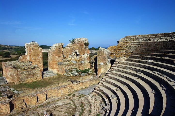
Nikopolis: An Extraordinary Time Capsule of Roman-Era Greece
Greece has applied to UNESCO to have Nikopolis included on its list of World Heritage sites marking places of enormous historical importance to the world.
The ancient city of Nikopolis located in Epirus the western part of the modern state of Greece, which was once home to as many as 150,000 people, is extraordinary in several ways. As it was founded in its classical form by the Romans at the end of their Republic, and flourished during the first years of the Roman Empire, it marks the beginning of the Empire itself.
Octavian’s crushing naval victory at Actium in 31 BC put an end to not only Mark Antony’s ambitions but to the whole Hellenistic era of the successors of Alexander. Less than a year later, on August 29, 30 BC, Octavian officially declared the end of the Ptolemaic dynasty, thus marking the end of the entire Hellenistic era.
Nikopolis (Nike-polis, “city of victory”) was created ex nihilo, by the first Roman Emperor Octavian, who was given the title of “Augustus,” in order to celebrate his victory and symbolize his autocracy. As the first city of this new era, sealing the establishment of the Empire under his reign, it was remarkable in scale and included a series of monuments created to glorify the Emperor.
Nicopolis Ticket Office
Nikopolis: An Extraordinary Time Capsule of Roman-Era Greece
Greece has applied to UNESCO to have Nikopolis included on its list of World Heritage sites marking places of enormous historical importance to the world.
The ancient city of Nikopolis located in Epirus the western part of the modern state of Greece, which was once home to as many as 150,000 people, is extraordinary in several ways. As it was founded in its classical form by the Romans at the end of their Republic, and flourished during the first years of the Roman Empire, it marks the beginning of the Empire itself.
Octavian’s crushing naval victory at Actium in 31 BC put an end to not only Mark Antony’s ambitions but to the whole Hellenistic era of the successors of Alexander. Less than a year later, on August 29, 30 BC, Octavian officially declared the end of the Ptolemaic dynasty, thus marking the end of the entire Hellenistic era.
Nikopolis (Nike-polis, “city of victory”) was created ex nihilo, by the first Roman Emperor Octavian, who was given the title of “Augustus,” in order to celebrate his victory and symbolize his autocracy. As the first city of this new era, sealing the establishment of the Empire under his reign, it was remarkable in scale and included a series of monuments created to glorify the Emperor.
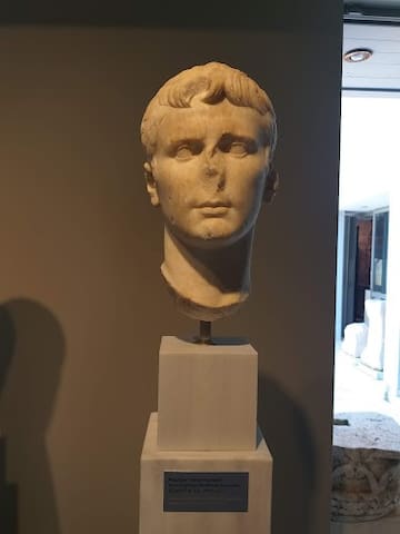
Preveza, Nikopolis Museum
The Archaeological Museum of Nicopolis is dedicated exclusively to Nicopolis, the city founded by Octavian in commemoration of his victory in the naval battle of Actium in 31 BC. With the central idea of the phrase "One battle, one city, one empire", it presents the history of this great city to the general public in a simple way.
17 locals recommend
Archaeological Museum of Nikopolis
IoanninonPreveza, Nikopolis Museum
The Archaeological Museum of Nicopolis is dedicated exclusively to Nicopolis, the city founded by Octavian in commemoration of his victory in the naval battle of Actium in 31 BC. With the central idea of the phrase "One battle, one city, one empire", it presents the history of this great city to the general public in a simple way.
The Roman Aqueduct of Nikopolis is a monumental architectural work of Roman times, which testifies to the single dependence of the current Prefecture of Preveza on Ancient Nikopolis.
Near the community of Agios Georgios in the Municipality of Ziros, the visitor is confronted with a stone structure with arched curves , which would be the envy of the best architects in the world today.
A work of impressive beauty, the Roman Aqueduct proves that the robust and rational Romans could and did "marry" this advantage with the beauty of conquered Greece.
From the springs of Louros in Agios Georgios, the Romans managed to water a city, which according to calculations reached 150,000 inhabitants. With a network of 50 km, which is a unique project for Epirus in the 2nd century AD, the power of Rome remained indelible in our region.
Remains of the aqueduct can be found in several places from Agios Georgios to Ancient Nikopolis.
Easy access by car through the old E.O. Preveza-Ioannina
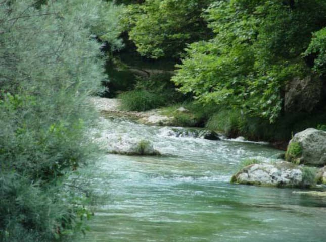
There are traditional water mills in the village of Agios Georgios
One can enjoy the Louros river and the beautiful natural landscape
There are traditional cafes and taverns in the village of Agios Georgios (1km distance)
Philippiada (seat of the Municipality of Ziros) is only 15 km away
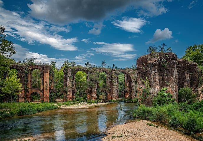
The Roman Aqueduct of ancient Nikopolis
The Roman Aqueduct of Nikopolis is a monumental architectural work of Roman times, which testifies to the single dependence of the current Prefecture of Preveza on Ancient Nikopolis.
Near the community of Agios Georgios in the Municipality of Ziros, the visitor is confronted with a stone structure with arched curves , which would be the envy of the best architects in the world today.
A work of impressive beauty, the Roman Aqueduct proves that the robust and rational Romans could and did "marry" this advantage with the beauty of conquered Greece.
From the springs of Louros in Agios Georgios, the Romans managed to water a city, which according to calculations reached 150,000 inhabitants. With a network of 50 km, which is a unique project for Epirus in the 2nd century AD, the power of Rome remained indelible in our region.
Remains of the aqueduct can be found in several places from Agios Georgios to Ancient Nikopolis.
Easy access by car through the old E.O. Preveza-Ioannina
There are traditional water mills in the village of Agios Georgios
One can enjoy the Louros river and the beautiful natural landscape
There are traditional cafes and taverns in the village of Agios Georgios (1km distance)
Philippiada (seat of the Municipality of Ziros) is only 15 km away
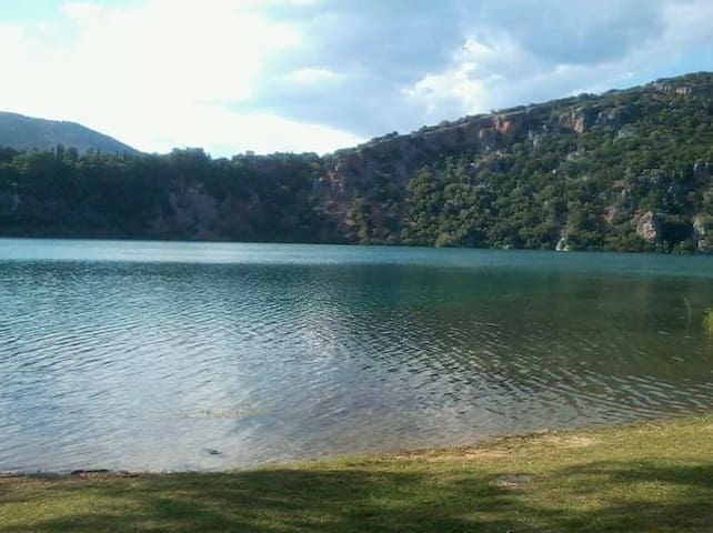
The lake of myths...
Lake Zirou, also referred to as Lake Ziros, is located in the east of the prefecture of Preveza and is a monument of nature, the beauty of which is comparable to lakes in central Europe and North America.
To its west rise the Thesprotic mountains and very close to its east flows the Louros river with which it communicates underground. A little further north is the famous Kokkinopilos, a group of red clay hills of great geological and archaeological interest.
It is probable that Lake Zirou was "covered", i.e. it was a cave, the roof of which collapsed 10,000 years ago, forming the current lake.
With a length of 900 meters and a width of 600, Lake Zirou creates a natural "mirror" with its waters, "enchanting" the visitor in a verdant forest of thousands of species of flora and fauna, which compose an amazing scene of well-being, relaxation, activities and enjoyment of the landscape. Lake Zirou is a unique park, not created by man, but by nature itself.
Its name is said to be of Slavic origin, proving the medieval presence of various tribes in Epirus and highlighting the historicity of the wider region. Moreover, the buildings of the former Paidopolis, which are located north of the Lake, are a memory of a turbulent time period of Hellenism, which was the Civil War.
The Lake is an integral "page" of the local "book" of popular tradition and folklore, as the myth of two brothers and an angel (referring to Sodom and Gomorrah) is used to justify their creation, according to the residents of the area.
Easy access by car
Ideal place for cycling, picnicking, hiking, relaxing and exercising
In close proximity to the town of Philippiada (only 2 km.)
On the eastern shore of the Lake there is a restaurant-cafe with a beautiful view of the Lake
There is the possibility of alternative sports activities ( canoe-cayak, archery, etc.)
In the summer months, the musical and cultural festival Zero Festival is organized
The Center for Environmental Education operates in the Lake
20 locals recommend
Limni Zirou
The lake of myths...
Lake Zirou, also referred to as Lake Ziros, is located in the east of the prefecture of Preveza and is a monument of nature, the beauty of which is comparable to lakes in central Europe and North America.
To its west rise the Thesprotic mountains and very close to its east flows the Louros river with which it communicates underground. A little further north is the famous Kokkinopilos, a group of red clay hills of great geological and archaeological interest.
It is probable that Lake Zirou was "covered", i.e. it was a cave, the roof of which collapsed 10,000 years ago, forming the current lake.
With a length of 900 meters and a width of 600, Lake Zirou creates a natural "mirror" with its waters, "enchanting" the visitor in a verdant forest of thousands of species of flora and fauna, which compose an amazing scene of well-being, relaxation, activities and enjoyment of the landscape. Lake Zirou is a unique park, not created by man, but by nature itself.
Its name is said to be of Slavic origin, proving the medieval presence of various tribes in Epirus and highlighting the historicity of the wider region. Moreover, the buildings of the former Paidopolis, which are located north of the Lake, are a memory of a turbulent time period of Hellenism, which was the Civil War.
The Lake is an integral "page" of the local "book" of popular tradition and folklore, as the myth of two brothers and an angel (referring to Sodom and Gomorrah) is used to justify their creation, according to the residents of the area.
Easy access by car
Ideal place for cycling, picnicking, hiking, relaxing and exercising
In close proximity to the town of Philippiada (only 2 km.)
On the eastern shore of the Lake there is a restaurant-cafe with a beautiful view of the Lake
There is the possibility of alternative sports activities ( canoe-cayak, archery, etc.)
In the summer months, the musical and cultural festival Zero Festival is organized
The Center for Environmental Education operates in the Lake
Kokkinopilos (Red clay) is a unique geological, natural and archaeological phenomenon in the Balkan peninsula.
Clay, nature and time took care of a "small miracle" in the "heart" of the Preveza Regional Unit. It is a complex of hills within the administrative limits of the Municipality of Ziros, which creates an almost lunar and otherworldly image to anyone who is lucky enough to step on these soils and go hiking.
Researchers believe that the phenomenon reaches back to the prehistoric period. The visitor "gets lost" between hills and ravines of red color. A "red earth", " terra rossa", as Spanish travelers called it. A... land where Kafka's saying "he who retains the ability to see beauty never grows old" would fit the landscape perfectly.
Important findings from the Paleolithic and Bronze Age have been found through the archaeological dig at the site of Asprochaliko near Kokkinopilos.
You can visit Kokkinopilos from two places:
From the side of E.O. Preveza-Ioannina, where you park near the village of Agios Georgios and walk for about 500 meters until you arrive.
From the provincial road Limni Zirou - Rizovouni - Stefani, where you leave your car at the point where there is a sign "to Kokkinopilos", you walk through the forest for about 1.5 km and you will find the hills of Kokkinopilos.
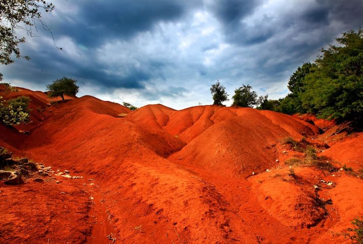
Kokkinopilos Preveza
Kokkinopilos (Red clay) is a unique geological, natural and archaeological phenomenon in the Balkan peninsula.
Clay, nature and time took care of a "small miracle" in the "heart" of the Preveza Regional Unit. It is a complex of hills within the administrative limits of the Municipality of Ziros, which creates an almost lunar and otherworldly image to anyone who is lucky enough to step on these soils and go hiking.
Researchers believe that the phenomenon reaches back to the prehistoric period. The visitor "gets lost" between hills and ravines of red color. A "red earth", " terra rossa", as Spanish travelers called it. A... land where Kafka's saying "he who retains the ability to see beauty never grows old" would fit the landscape perfectly.
Important findings from the Paleolithic and Bronze Age have been found through the archaeological dig at the site of Asprochaliko near Kokkinopilos.
You can visit Kokkinopilos from two places:
From the side of E.O. Preveza-Ioannina, where you park near the village of Agios Georgios and walk for about 500 meters until you arrive.
From the provincial road Limni Zirou - Rizovouni - Stefani, where you leave your car at the point where there is a sign "to Kokkinopilos", you walk through the forest for about 1.5 km and you will find the hills of Kokkinopilos.
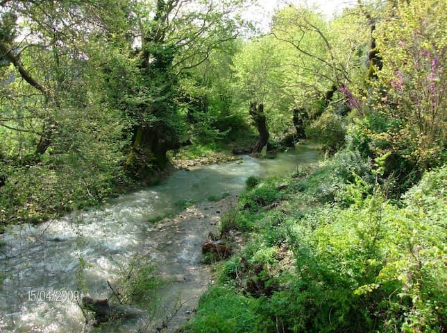
The Lekatsa forest of particular natural beauty is located near the village of Myrsini at a distance of 35 kilometers from the city of Preveza.
It is a forest of rare flora and is a natural game reserve. Overgrown with plane trees and oaks, it is crossed by the river Arethon, which in its passage gives a special beauty to the landscape. It is worth it, for nature lovers and not only, to visit the forest and they will surely be compensated by what they will see. It is a forest of rare flora and is a natural game reserve. For the convenience of visitors, there is a forest road that circles the forest and various recreational projects. Nearby is the Lekatsa Monastery.
Lekatsa Dimou Zalongou
The Lekatsa forest of particular natural beauty is located near the village of Myrsini at a distance of 35 kilometers from the city of Preveza.
It is a forest of rare flora and is a natural game reserve. Overgrown with plane trees and oaks, it is crossed by the river Arethon, which in its passage gives a special beauty to the landscape. It is worth it, for nature lovers and not only, to visit the forest and they will surely be compensated by what they will see. It is a forest of rare flora and is a natural game reserve. For the convenience of visitors, there is a forest road that circles the forest and various recreational projects. Nearby is the Lekatsa Monastery.
The Greek ''Matsu Pitsu"...
Kassopi is the ancient Greek city with the most beautiful view. A real natural "balcony" where the visitor gets lost in the magic of the diversity of the landscapes.
The founders of Ancient Kassope in the first half of the 4th century BC. they chose the location carefully. A naturally fortified location, at an altitude of 650 meters, under the steep rocks of Mount Zalogos and oriented towards the well-being of the inhabitants.
Kassopi has an impressive ancient architecture, as it is built with the Hippodamian system and is divided into 20 parallel streets, the "narrows". The Kassopeans, a quintessentially continental race, created a great economic and commercial center, with a civil market, rectory, two theaters, a hostel, temples of worship, and its own mint. Especially the great ancient theater of Kassope is a real work of art. The city was destroyed in 167 BC . by the Romans and was completely deserted in 31 BC. when the remaining inhabitants were forcibly transferred as settlers to the newly founded Roman city of Ancient Nicopolis.
In the archaeological site, which emerges through beautiful clusters of trees, the visitor browses among impressive finds of antiquity, which are preserved in excellent condition, always having an amazing view.
One of the few ancient cities, where the visitor can really feel what life was like in the ancient world.
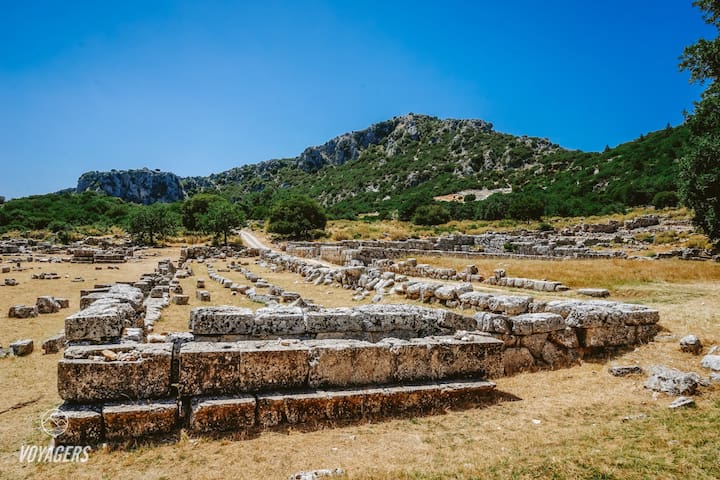
Αρχαίο Θέατρο Κασσώπης
The Greek ''Matsu Pitsu"...
Kassopi is the ancient Greek city with the most beautiful view. A real natural "balcony" where the visitor gets lost in the magic of the diversity of the landscapes.
The founders of Ancient Kassope in the first half of the 4th century BC. they chose the location carefully. A naturally fortified location, at an altitude of 650 meters, under the steep rocks of Mount Zalogos and oriented towards the well-being of the inhabitants.
Kassopi has an impressive ancient architecture, as it is built with the Hippodamian system and is divided into 20 parallel streets, the "narrows". The Kassopeans, a quintessentially continental race, created a great economic and commercial center, with a civil market, rectory, two theaters, a hostel, temples of worship, and its own mint. Especially the great ancient theater of Kassope is a real work of art. The city was destroyed in 167 BC . by the Romans and was completely deserted in 31 BC. when the remaining inhabitants were forcibly transferred as settlers to the newly founded Roman city of Ancient Nicopolis.
In the archaeological site, which emerges through beautiful clusters of trees, the visitor browses among impressive finds of antiquity, which are preserved in excellent condition, always having an amazing view.
One of the few ancient cities, where the visitor can really feel what life was like in the ancient world.
The monumental complex at the top of Mount Zalogos stands tall and conveys to the whole world a universal message of sacrifice and freedom.
The international symbolism of the sacrifice of women in Zalogos, is a center of interest for historians, writers and politicians throughout the world, appears in world masterpieces of art and has made Preveza and Souli known worldwide.
The Zalongos Monument stands at the top of the homonymous mountain at an altitude of 765 meters. It depicts, on a stone-built base, 4 gigantic abstract figures of the Souliotissas and has a reference to the sacrifice of Zalongos . In 1803 the Souliotisses (about 60 in number according to historical sources) surrounded in Zalogs by the Ottoman army, preferred to fall with their babies on the cliff and sacrifice themselves, rather than live a life of captivity and dishonor. According to historical legend, they danced before falling off the cliff, something that was later captured and glorified by world literature.
The famous sculptor Georgios Zongolopoulos worked on the construction of the Monument from 1954 to 1960. The inauguration took place on June 11, 1961, in the presence of King Paul, Queen Frederica, the metropolitans of all of Epirus and other dignitaries .
It is 28 kilometers by road from the city of Preveza (access from Archangelos-Neraidas Road and through the community of Kamarinas).
Access by car is to the Holy Monastery of Agios Dimitrios and the visitor must then climb 410 steps (15-20 minutes) to reach the Monument.
Entrance to the Monument is free.
At 200 meters from the Monument at the top there is the Taxiarchi Michael monastery as a religious attraction.
In Kamarina (distance 3 km.) there are restaurants (cafes-taverns).
You can combine the visit to the Zalongos Monument with a visit to the Archaeological site of Kassopi.
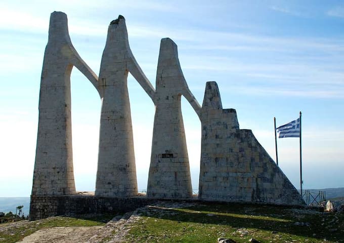
Zalongo Monument
The monumental complex at the top of Mount Zalogos stands tall and conveys to the whole world a universal message of sacrifice and freedom.
The international symbolism of the sacrifice of women in Zalogos, is a center of interest for historians, writers and politicians throughout the world, appears in world masterpieces of art and has made Preveza and Souli known worldwide.
The Zalongos Monument stands at the top of the homonymous mountain at an altitude of 765 meters. It depicts, on a stone-built base, 4 gigantic abstract figures of the Souliotissas and has a reference to the sacrifice of Zalongos . In 1803 the Souliotisses (about 60 in number according to historical sources) surrounded in Zalogs by the Ottoman army, preferred to fall with their babies on the cliff and sacrifice themselves, rather than live a life of captivity and dishonor. According to historical legend, they danced before falling off the cliff, something that was later captured and glorified by world literature.
The famous sculptor Georgios Zongolopoulos worked on the construction of the Monument from 1954 to 1960. The inauguration took place on June 11, 1961, in the presence of King Paul, Queen Frederica, the metropolitans of all of Epirus and other dignitaries .
It is 28 kilometers by road from the city of Preveza (access from Archangelos-Neraidas Road and through the community of Kamarinas).
Access by car is to the Holy Monastery of Agios Dimitrios and the visitor must then climb 410 steps (15-20 minutes) to reach the Monument.
Entrance to the Monument is free.
At 200 meters from the Monument at the top there is the Taxiarchi Michael monastery as a religious attraction.
In Kamarina (distance 3 km.) there are restaurants (cafes-taverns).
You can combine the visit to the Zalongos Monument with a visit to the Archaeological site of Kassopi.
Lefkada
With a 20 minutes drive or by bus, you can visit, the iland of Lefkada
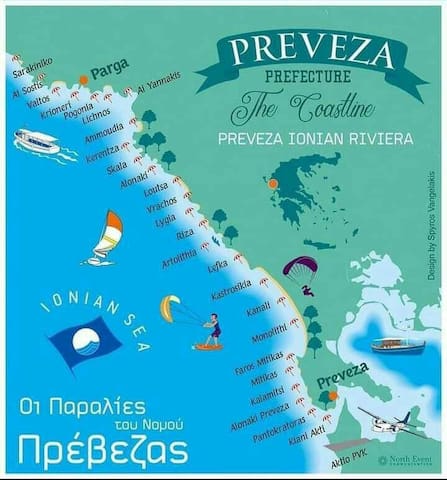
Maps
Here is a map with the coastline of Preveza and all the beaches you can visit!
28 locals recommend
Monolithi Beach
Here is a map with the coastline of Preveza and all the beaches you can visit!
City advice
Getting around
How to move
There are four ways for your transportation at Preveza:
-Use the local bus
-Take a taxi
-Rend a car
For reaching the main area of the city (downtown, the Marina, the historical center, and also the closest beach) you can walk, there is no need for any kind of transportation.